Crater Lake National Park is one of the wonders of the natural world. Once a large stratovolcano (known as Mount
Mazama) reached a height of over 12000 feet (3700 m), but a massive eruption 7700 years ago destroyed the summit
cone and emptied the magma chamber below, causing the entire mountain to collapse. This formed the 6 mile (10 km)
wide caldera which eventually filled with the brilliant blue waters of 1932 foot (589 m) deep Crater Lake, the
deepest in the US. The lake surface now lies at 6178 feet (1883 m), with the surrounding rim varying from about
7000-8000 ft (2100-2400 m). Massive annual snowfall averaging over 530 inches (13 m) per year buries the area,
making ski circumnavigations of the crater rim feasible in winter and spring. However, these deep snows also close
Rim Drive well into summer, preventing easy vehicle access to ski mountaineering objectives such as Mount Scott,
the highest surviving remnant of the original Mount Mazama. However, a number of other skiable high points on the
crater rim remain easily accessible throughout the winter and spring.
| Route |
Ratings |
Starting
Elevation |
Elevation
Gain/Loss |
Roundtrip
Distance |
Notes |
| Quality |
Effort |
Ascent |
Descent |
| Ski Mountaineering / Cross-Country Skiing Routes: |
Circumnavigation
(along the Crater Rim,
start from Rim Village) |
 |

12.0 |
 |
|
7100 ft
(2150 m) |
+4000 ft
(+1200 m)
-4700 ft
(-1400 m) |
31 miles
(50 km) |
The circumnavigation of the rim of Crater Lake is one of the classic cross-country ski
routes in the US. The circuit follows the snow-covered Rim Drive, which generally stays
within sight of the edge of the rim, except for a few sections on the south and east sides
where it must detour far from the lake. The route is generally done in about 2-3 days,
although cross-country racers have done it in less than 8 hours. Many parts of the road
are difficult to follow when snow-covered, so this is definitely a backcountry tour.
For the ski mountaineer, there are many steeper slopes dropping from the various high
points along the rim which would provide enough good turns to make the loop worthwhile
(as if the scenery alone wasn't enough!).
|
Mount Scott
(Northwest Bowl
from Kerr Notch) |
 |

4.5 |
|
 |
6700 ft
(2050 m) |
2300 ft
(700 m) |
9 miles
(14 km) |
Mount Scott is the most prominent high point in Crater Lake National Park,
although it lies about 2 miles (3 km) east of the crater rim. It is a satellite cone of
the original Mount Mazama, and survived largely unscathed due to its position east of
the subterranean magma chamber. A large glacial cirque (which also predates the climactic
eruption of Mazama) has been carved into the northwest side, exposing some of the
solidified magma in the central conduits. This cirque makes an excellent albeit somewhat
short ski descent, but due to its somewhat windward exposure tends to lose snowcover
before summer (before the road opens to its base). The best option for good access and
snow conditions is to go in spring as the plowing progresses, and drive as far as the Park
Service will allow (usually to Kerr Notch). On the relatively smooth and uneroded north,
east, and southeast sides, long treeless slide paths descend from the summit well into the
forests below, providing somewhat longer ski runs with the penalty of reascent to return
to the trailhead on Rim Drive. It may be possible to reach these routes from the Scott
Creek and/or Pothole Creek drainages, which appear to offer very direct access.
|
Mount Scott
(north / northeast side
from Kerr Notch) |
 |
6.0 |
|
|
+2300 ft
(+700 m)
-800 ft
(-250 m) |
11 miles
(18 km) |
Mount Scott
(east / southeast side
from Scott Creek) |
|
4.5 |
|
|
6100 ft
(1850 m) |
2800 ft
(850 m) |
6 miles
(9 km) |
Garfield Peak /
Applegate Peak
(from Park HQ) |
|
4.0 |
 |
|
6400 ft
(1950 m) |
1700 ft
(500 m) |
8 miles
(12 km) |
These short and easy routes start from the Park Headquarters south of
Rim Village and follow the snowcovered Rim Drive east. The broad snow slope leading to
Garfield and Applegate peaks appears in only 1 mile, while the similarly gentle Dutton Ridge
is about 5.5 miles up the road (after a short descent past Sun Notch). Stunning views
of the lake can be found from all three high points and from the overlook at Sun Notch.
|
Dutton Ridge
(from Park HQ) |
|
5.5 |
|
|
1900 ft
(600 m)
-200 ft
(-50 m) |
14 miles
(22 km) |
The Watchman
(from Rim Village) |
|
3.0 |
|
|
7100 ft
(2150 m) |
1000 ft
(300 m) |
7 miles
(11 km) |
This route follows the snow-covered Rim Drive west from Rim Village,
passing the Wizard Island Overlook in about 2.5 fairly flat miles. Hillman Peak is the
highest point on the rim of Crater Lake, while the Watchman has a lookout cabin on its
summit. Short ascents of about 800 ft (250 m) from Rim Drive lead to either summit, and
steep slopes provide a short but sweet ski run, especially on the northwest side of each
peak. These faces usually remain skiable after the park road opens, and the outlines of
ski turns often linger in the snow well into midsummer.
|
Hillman Peak
(from Rim Village) |
|
3.5 |
|
|
1100 ft
(350 m) |
9 miles
(14 km) |

|
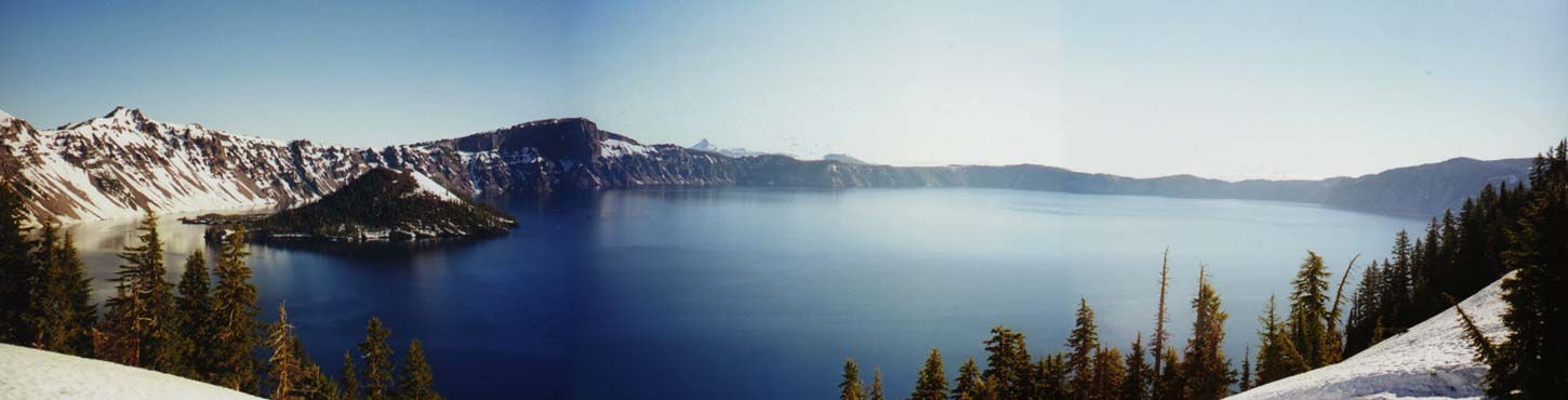
Panoramic view of Crater Lake from the south rim (just east of Crater Lake Lodge) in June,
digitally composited from three photographs:
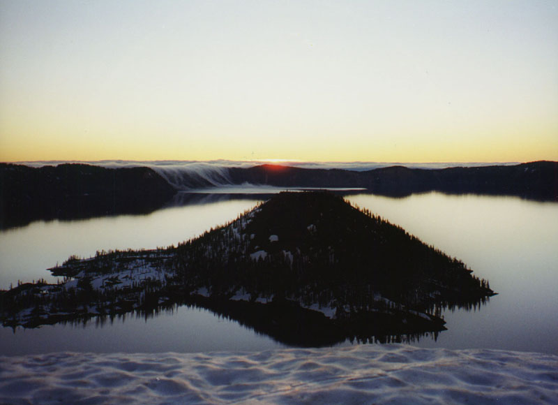
Wizard Island is the prominent satellite cone
in the lake at left center; Mount Thielsen is visible in the distance beyond the crater rim at center
(photo by Amar Andalkar) <click to enlarge>
|

|
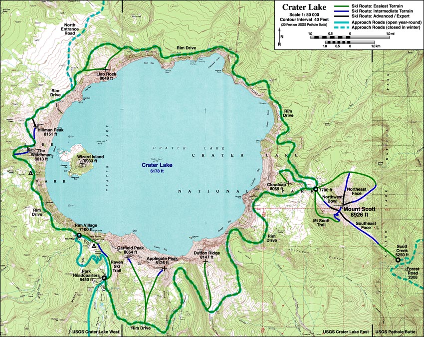
Topographic map of Crater Lake
showing ski routes listed in table above
<click map to enlarge, 216 kB file>
|
|

|
Aerial view of Crater Lake from the east,
with Mount Scott at lower left
(photo by S. C. Porter) <click to enlarge>
|
Useful Web Links:
List of Guidebooks: (detailed references on the
bibliography page)
List of Maps:
| Map Series |
Scale |
Topo? |
Map Names |
Year |
Notes |
| USGS 7.5-minute |
1:24,000 |
Yes, 40 ft |
Crater Lake West
Crater Lake East
Pothole Butte |
1985
1985
1985 |
First two maps cover all of Crater Lake and most
of Mount Scott, while third map covers eastern part |
| USGS Natl Park |
1:62,500 |
Yes, 50 ft |
Crater Lake National Park |
1988 |
Very useful, nicely covers entire park on one map,
including east approach to Mount Scott;
excellent info about Crater Lake's formation on back |
| Trails Illustrated |
1:62,500 |
Yes, 50 ft |
Crater Lake National Park |
1997? |
A copy of the USGS map above, easier to find in stores,
but costlier and with less useful information on back |
| US Forest Service |
1:126,720 |
No |
Winema National Forest |
1994 |
Somewhat useful for forest road information
for east approach to Mount Scott |
More photos, routes, links, references, etc. coming soon...
Please contact me with any suggestions, additions, or corrections.
|