Broken Top is the oldest and most eroded of the five major volcanoes in the Three Sisters region.
Several hundred-thousand years ago its summit probably topped 10000 ft (3000 m) as do the present summits of the
Three Sisters, but glacial erosion has now removed all of the original surface and carved deep into the interior,
revealing the innermost structure of the volcano. The highest remaining points form a horseshoe open to the south,
surrounding what was once the crater of the original volcano. Glaciers continue to grind away at Broken Top today:
the Crook Glacier occupies the central portion of the crater bowl, while the Bend Glacier flows in a series of
jagged tongues down the steep northern flanks of the summit ridge. Although the uppermost rotten lava pinnacles are
never quite skiable, there are a number of worthwhile ski routes both inside the steep confines of the crater and
along the somewhat gentler ridges and flanks on the outside. In addition, Broken Top has relatively easy access
throughout the winter and early spring from the Mount Bachelor Ski Area, while all of the roads accessing the
central portion of the Three Sisters Wilderness are snowcovered for many miles.
| Route |
Ratings |
Starting
Elevation |
Elevation
Gain |
Roundtrip
Distance |
Notes |
| Quality |
Effort |
Ascent |
Descent |
| Ski Mountaineering Routes:
NOTE: All ratings are for ski routes only up to the base of the summit pinnacle. |
South Ridge / SW Face
(spring access from Todd Lake) |
 |

5.0 |
 |
 |
6100 ft
(1850 m) |
2700 ft
(800 m) |
10 miles
(16 km) |
This is the most prominent route on visible on Broken Top from the highway,
dropping in a direct line from the Southwest Summit. In spring it is possible to ski
from just below he highest summit rocks, although its windward and southern exposure
results in early loss of snowcover. Unfortunately the access is not as direct as the
ski line, requiring a long traversing ascent from Todd Lake once the road is plowed in
late spring. In winter (when the route is likely to be more skiable), the approach is 2
miles (3 km) longer, starting from the Mount Bachelor Ski Area or nearby Dutchman Flat
Snow Park.
|
(winter access from Mt Bachelor
Ski Area or Dutchman Flat) |
|

6.5 |
|
|
6400 ft
(1950 m) |
2900 ft
(900 m)
-300 ft
(-100 m) |
14 miles
(22 km) |
Crater Bowl / Crook Glacier:
First Notch (9 O'Clock Couloir)
(spring access from Todd Lake) |
|
5.5 |
|
 |
6100 ft
(1850 m) |
2500 ft
(750 m) |
11 miles
(18 km) |
The huge eroded Crater Bowl holds a variety of skiable lines, most of
which are very steep and exposed to avalanche, and rockfall hazard. These two
gully are the most prominent and safest of these choices, although the First Notch often
has huge cornices at the top in early season. The Crater Bowl holds skiable snow into
late spring and even early summer, when the avalanche and cornice hazard is somewhat less,
so it is probably preferable to go after the road is plowed to Todd Lake.
|
Crater Bowl / Crook Glacier:
South Face Gully
(spring access from Todd Lake) |
|
5.5 |
|
 |
2700 ft
(800 m) |
11 miles
(18 km) |
SW Face and Ridge
(spring access from Sparks Lake) |
|
5.5 |
|
 |
5400 ft
(1650 m) |
3400 ft
(1050 m) |
8 miles
(13 km) |
The shortest access to routes on the west side of Broken Top is via the
Green Lakes trail, starting from the highway at the north end of Sparks Lake.
Unfortunately the road is not usually plowed until late spring, adding 4 miles each way
plus 900 ft of elevation loss (coming in) and gain (going out) to early season trips. That
said, some of the best ski terrain on Broken Top is found on this side. The fall line of
the Southwest Face drops naturally to this side, providing a more direct runout instead of
the traverse needed to return to the Todd Lake side. The West Face has a variety of
skiable lines, descending from high up on both the main (north) summit and the southwest
summit and also from the various notches along the ridge in between. The Northwest
Ridge provides the gentlest ascent, and leads to the easiest summit climbing route, but
has the longest access of these three routes. All routes on this side lose their
snowcover somewhat early due to the windward aspect, especially on the upper parts, but
the NW Ridge is most prone to this problem. In that case one can climb the ridge and
ski down via the edge of the West or North Face.
|
West Face
(spring access from Sparks Lake) |
|
6.0 |
|
|
3600 ft
(1100 m) |
10 miles
(16 km) |
Northwest Ridge
(spring access from Sparks Lake) |
 |
6.5 |
|
|
12 miles
(20 km) |
Northwest Ridge
(spring access from Pole Creek) |
|
9.0 |
|
|
5300 ft
(1600 m) |
4000 ft
(1200 m)
-300 ft
(-100 m) |
18 miles
(29 km) |
The North Face of Broken Top is extremely steep, with many areas of
near-vertical crumbling volcanic rock above the shattered segments of the Bend Glacier.
However, the westernmost portion of the face, just along the Northwest Ridge, offers the
possibility of a ski descent from the very edge of the summit block of Broken Top. Access
to this area is very long, starting along the Green Lakes trail from either the south or
north end (at Pole Creek).
|
North Face
(spring access from Pole Creek) |
|
8.5 |
|
|
17 miles
(27 km) |
Tam McArthur Rim
and Broken Hand
(winter access from
Upper Three Creek Snowpark) |
|
8.0 |
 |
|
5100 ft
(1550 m) |
3300 ft
(1000 m) |
18 miles
(29 km) |
Tam McArthur Rim is a prominent north-facing lava escarpment and plateau which lies on
the northeastern side of Broken Top and forms a spectacular, high viewpoint for the entire
length of the north-central Oregon Cascades. This long, gentle route leads up the
snowcovered Three Creek Road and then the contours around the east edge of the Rim to gain
the plateau. Steeper ascent and descent options head more directly southwest from Three
Creek Lake. The open slopes of the plateau can be followed west to Broken Hand, an outlier
peak separated from the main massif of Broken Top by a recently deglaciated cirque
containing a large alpine lake.
|
Ball Butte
(winter access from Mt Bachelor
Ski Area or Dutchman Flat) |
|
4.5 |
|
|
6400 ft
(1950 m) |
1700 ft
(500 m) |
10 miles
(16 km) |
Ball Butte is the most southeasterly peak in the Broken Top massif, and the closest to
the Cascade Lakes Highway. The west side is a steep cliff, but the eastern half is a
gentle slope whose leeward aspect builds up a deep snowpack. A variety of lines are
skiable on Ball Butte and neighboring high points, and access is easy in all seasons.
|
|
Upcoming additions: |
Topographic map showing all ski routes. |

|
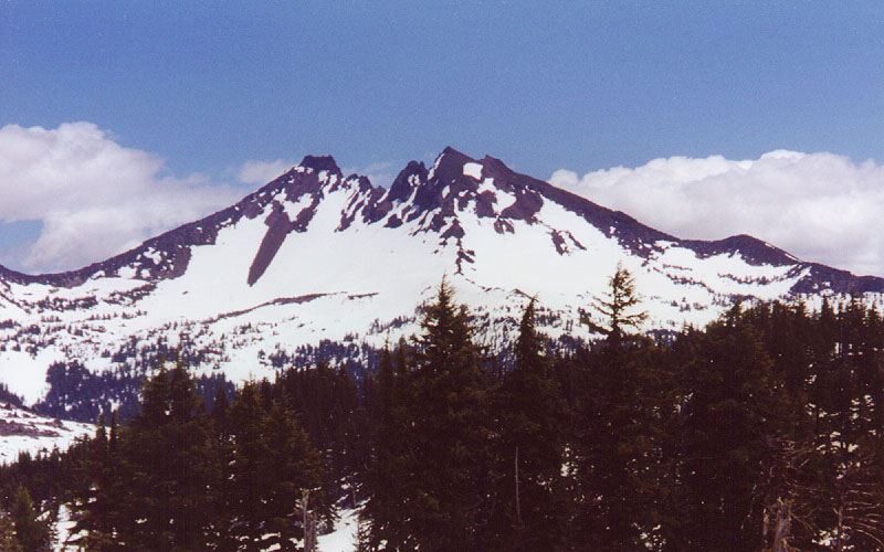
The west face of Broken Top seen from the large plateau above
Moraine Lake, with true summit at left and SW summit at right
(photo by Amar Andalkar) <click to enlarge>
|
|

|
Northwest view of Broken Top from the summit of South Sister
NW Ridge faces camera, with north face and Bend Glacier at left
(photo by Amar Andalkar) <click to enlarge>
|
Useful Web Links:
List of Guidebooks: (detailed references on the
bibliography page)
List of Maps:
| Map Series |
Scale |
Topo? |
Map Names |
Year |
Notes |
| USGS 7.5-minute |
1:24,000 |
Yes, 40 ft |
Broken Top |
1988 |
Very useful, Broken Top is nicely centered,
and all trailheads fit on the map, too. Note that
most snow shown on this map is not permanent. |
Geo-Graphics
(double-sided) |
1:26,966
1:84,480 |
Yes, 40 ft
Yes, 80 ft |
Three Sisters Wilderness |
1994
|
Useful for a regional overview, and also for
navigation on tours combining with the Three Sisters |
| US Forest Service |
1:126,720 |
No |
Deschutes National Forest |
1988 |
Somewhat useful for forest road information |
More photos, routes, links, references, etc. coming soon...
Please contact me with any suggestions, additions, or corrections.
|