The Goat Rocks are the eroded remnants of a once-great stratovolcano. One to two million years ago, this cone
would likely have been similar in height and structure to typical present-day Cascade stratovolcanoes, reaching
over 10000 ft high. But once the eruptive activity ceased, the forces of glacial erosion tore away the outer
layers of material, leaving exposed the rocky lava spires where magma once solidified within the conduits of the
volcano. The present eroded massif has several peaks reaching about 8000 ft, and the north sides are still host to
about a half-dozen glaciers. Most of the approaches into the Goat Rocks Wilderness are somewhat long in trail
mileage, so the routes below are all probably best done as overnight (or multi-day) trips, despite the
comparatively moderate elevation gains.
| Route |
Ratings |
Starting
Elevation |
Elevation
Gain |
Roundtrip
Distance |
Notes |
| Quality |
Effort |
Ascent |
Descent |
| Ski Mountaineering Routes:
|
Mt Curtis Gilbert
via Conrad Glacier |
 |

8.0 |
 |
 |
4000 ft
(1200 m) |
4300 ft
(1300 m) |
15 miles
(24 km) |
The shortest and most direct route to the Goat Rocks' high point.
The route follows a creek for miles from Conrad Meadows, all the way
to the relatively gentle and inactive north-side glacier. It then heads straight
up the glacier towards the summit. See vol.1, p.71 of the Cascade Alpine Guide
(CAG) for a fine route photo. |
Mt Curtis Gilbert
via Meade Glacier |
 |
9.0 |
|
|
4000 ft
(1200 m) |
4300 ft
(1300 m) |
18 miles
(29 km) |
A somewhat longer and more circuitous route than the previous, starting from the
same trailhead but ending up on the east side of Curtis Gilbert. Perhaps not
that great of a ski route, although CAG does mention good glissading terrain on the
northerly edge of the Meade Glacier. |
Old Snowy Mtn
or Ives Peak
via Snowgrass Flat |
|

6.5 |
 |
 |
4600 ft
(1400 m) |
3700 ft
(1100 m) |
12 miles
(20 km) |
The standard hiking and skiing route into the Goat Rocks, reaching the Pacific Crest
Trail at Snowgrass Flat (5800 ft). Follow obvious gentle gullies to Old Snowy-Ives Col
on the ridge above and then continue to either Old Snowy Mtn or Ives Peak.
From Snowgrass Flat, many ski runs are possible. |
Mt Curtis Gilbert
via Snowgrass Flat
and Tieton Glacier |
|
10.0 |
|
|
4600 ft
(1400 m) |
4800 ft
(1500 m) |
19 miles
(30 km) |
This route follows PCT southeast from Snowgrass Flat, then ascends north to the ridge
crest before reaching Cispus Pass. It then drops onto the Tieton Glacier on the
north of the crest, and traverses/climbs east to Mt Curtis Gilbert. |
Old Snowy Mtn
from the north
via McCall Glacier |
 |
9.0 |
|
|
3300 ft
(1000 m) |
4600 ft
(1400 m) |
17 miles
(27 km) |
This route starts from the N Fork Tieton River, climbing to Tieton Pass and then traversing
south into McCall Basin. It then climbs directly up the McCall Glacier to the summit.
A longer approach, starting from the top of the lifts at White Pass ski area and
traversing the long ridge to Tieton Pass, is also possible in winter or early spring. |
|
Upcoming additions: |
Topographic map showing all ski routes. |
|

|
Panoramic version of the photo at top, showing the west side of the Goat Rocks in June
with Old Snowy Mountain at left and Ives Peak at right
(digitally composited from 3 photos by Amar Andalkar)
<click to enlarge>
|
|

|
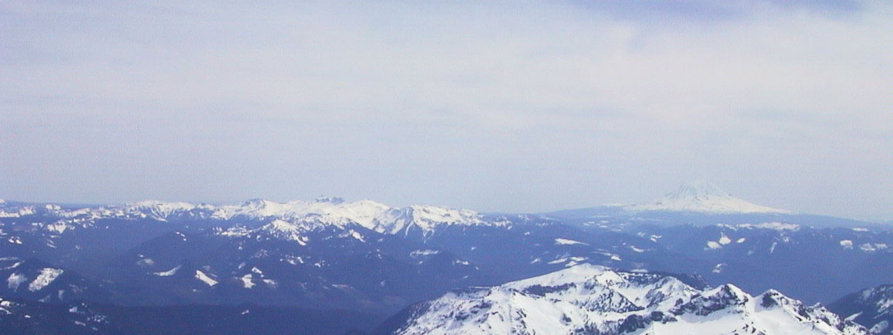
Panoramic view looking south from Mount Rainier, with the Goat Rocks massif
at left and Mount Adams visible in the distance at right;
the Tatoosh Range in Mount Rainier National Park is seen at lower right
(photo by Amar Andalkar) <click to enlarge>
|
Useful Web Links:
List of Guidebooks: (detailed references on the
bibliography page)
More photos, routes, links, references, etc. coming soon...
Please contact me with any suggestions, additions, or corrections.
|