Skiing the Cascade Volcanoes
        Amar Andalkar's Ski Mountaineering and Climbing Site
Ski Mountaineering Photos & Trip Reports Equipment & Info Cascade Volcanoes Ring of Fire Site Map

Table of Contents | Introduction | Ratings | WebCams | Bibliography | Highest Volcanoes | Snowfall & Snowdepth | Monthly Chart | Conifers | Compare | Distance | Sun Chart
CALIFORNIA
  Lassen Peak
  Mount Shasta
  Medicine Lake Volcano
OREGON
  Mount McLoughlin
  Pelican Butte
  Crater Lake
  Mount Bailey
  Mount Thielsen
  Diamond Peak
  Newberry Volcano
  Mount Bachelor
  Broken Top
  Three Sisters
  Mount Washington
  Three Fingered Jack
  Mount Jefferson
  Mount Hood
WASHINGTON
  Mount Saint Helens
  Mount Adams
  Goat Rocks
  Mount Rainier
  Glacier Peak
  Mount Baker
BRITISH COLUMBIA
  Mount Garibaldi
  Mount Cayley
  Mount Meager


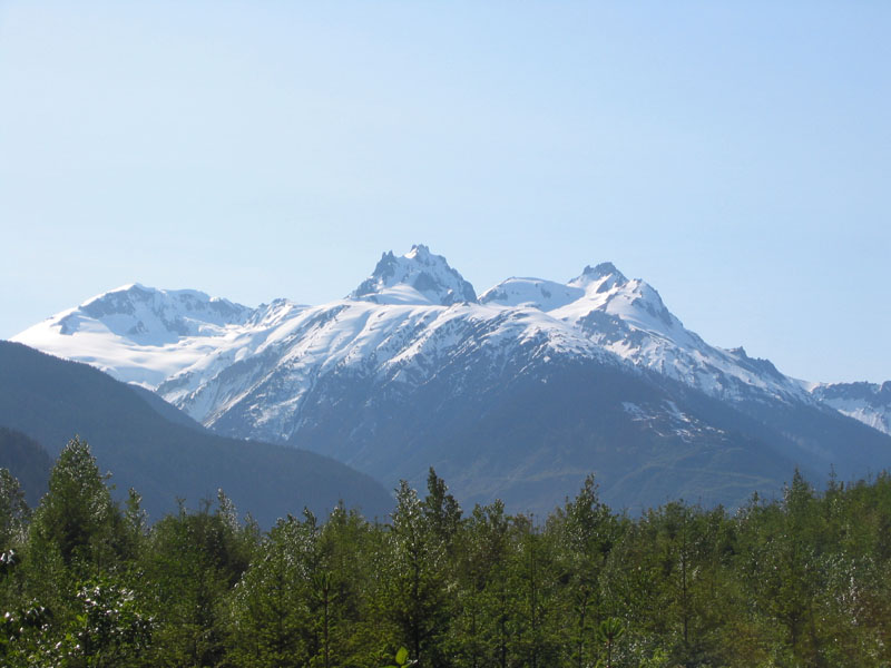
| The Mount Meager Volcanic Complex rises above the head of
the Lillooet River valley in June, with Pylon Peak at left,
Mount Meager at center, and Plinth Peak at right
(photo by Amar Andalkar)   <click to enlarge>

Mount Meager   Volcanic Complex
    8790 ft (2679 m) .
Major Peaks:
Plinth Peak:     8790 ft (2679 m)
Mount Meager:     8680 ft (2646 m)
Capricorn Mtn:     8429 ft (2569 m)
Mount Job:     8180 ft (2493 m)
Pylon Peak:     8112 ft (2473 m)
Location: Coast Mountains, southwestern British Columbia,
40 miles (65 km) NW of Pemberton
Lat / Long: 50.6° N, 123.6° W
Volcanic Type: Stratovolcano complex
Volcanic Status: Dormant, last eruption 2350 years ago
First Ascent: N. Carter, A. Dalgleish, T. Fyles,
and M. Winram, 1931
First Ski Descent: Unknown, probably not skiable from summit
Skiable Vertical: over 7000 ft (2100 m)
Timberline: 5000-6000 ft (1500-1800 m)
Administration: British Columbia Ministry of Forests
Protection Status:   none
User Fees: $5 day use fee for Meager Creek Hot Springs area

Info about the Mount Meager Volcanic Complex ...


Route Ratings Starting
Elevation
Elevation
Gain
Roundtrip
Distance
Notes
Quality Effort Ascent Descent
Ski Mountaineering Routes:  
Route Info
10.5
4100 ft
(1250 m)
5900 ft
(1800 m)
19 miles
(30 km)
Route info...                                                                              

Upcoming additions: Topographic map showing all ski routes.

More photos, routes, links, references, etc. coming soon...
Please contact me with any suggestions, additions, or corrections.


Previous Page (Mount Cayley) | Mount Meager | Next Page (Contents)
Table of Contents | Introduction | Ratings | WebCams | Bibliography | Highest Volcanoes | Snowfall & Snowdepth | Monthly Chart | Conifers | Compare | Distance | Sun Chart
Ski Mountaineering Photos & Trip Reports Equipment & Info Cascade Volcanoes Ring of Fire Site Map

Amar Andalkar   Seattle, WA, USA   <About the Author / Contact Me>
All material on this website is ©1997-2024 by Amar Andalkar unless otherwise noted.
Page content last modified: Wednesday, January 15, 2003
PHP script last modified: Tuesday, February 4, 2020